
|
JunkScience.com
September 12, 2004
UHIE is the acronym for Urban Heat Island Effect.
Very simply, UHIE is the result of buildings and pavement absorbing greater amounts of broad spectrum solar radiation than vegetation does. This makes a difference because the atmosphere does not absorb solar radiation across the spectrum but greenhouse gasses (GHGs such as water vapor, carbon dioxide, methane...) absorb infrared. As buildings and pavement re-radiate absorbed broad spectrum radiation in the infrared band absorbable by GHGs we get an increase in the solar energy available to warm the air in cities and towns. With perpendicular walls increasing collector area, acting as trombe walls (storing and re-radiating energy at night) and excluding cooling breezes and with blacktop paved areas reducing surface albedo (reflection), cities and towns have become highly effective accumulators of solar warmth.
In a word - no. All it does is remind us of something we've known and observed for ages - partially enclosed spaces warm up more in the sun than similar open spaces do.
It can be very significant. For example, here's a NASA item on "Hotlanta" stating that urban Atlanta can reach 5 to 8 degrees Fahrenheit (~2.8 to 4.4 °C) or higher than surrounding rural areas. It's been quite topical too, "HOT-LANTA EFFECT - Urban heat: Growing season, hardiness affected" - "Heat from cities is lengthening the growing season and allowing for more warm-weather plants" (The Atlanta Journal-Constitution) - see Urban Heat Islands Make Cities Greener (NASA GSFC release).
The above release suggests that UHIE exerts an influence over an area almost 2.5 times the size of the city and we surmise it's likely to be similar for towns and villages too. This suggests that (being generous) up to 10% of the Earth's non-ice land surface may be affected to some extent - perhaps 3% of the total globe surface. Because the atmospheric column is not uniformly affected, merely the near-surface portion over the city and tapering off on the downwind "plume," significantly less than 3% of the troposphere will exhibit UHIE.
To what extent this effect is mitigated by increased albedo from croplands where more absorptive forest and scrub once grew is difficult to establish but anyone who has stood in the midst of a few thousand acres of ripe wheat on a hot summer's day can tell you that the albedo is indeed significant.
According to the NASA Goddard Institute for Space Studies (GISS) Surface Temperature Analysis page, not very:
"The Figures below indicate:
(a) the number of stations with record length at least N years as a function of N ,
(b) the number of reporting stations as a function of time,
(c) the percent of hemispheric area located within 1200km (~750miles) of a reporting station.
 "
"
Compared with the near-global coverage of NOAA satellite-mounted MSUs (the "satellite record"), reporting stations on a grid of about 1500miles is not particularly good coverage. Given that so many near-surface stations are located in urban settings and even airports it is unavoidable that the near-surface record is affected by UHIE.
It is difficult to see how it could not. The late John L. Daly explored this problem in a report to the Greening Earth Society "The Surface Record: ‘Global Mean Temperature’ and how it is determined at surface level"
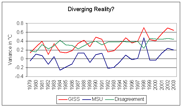
Is UHIE the reason for the increasing discrepancy between the MSU record and GISS GISTEMP?

As the above graph indicates, the only time in the last decade that agreement between the records has improved was when the troposphere reacted to the powerful 1997/98 El Niño event. With the MSU record in good agreement with data from radio-sonde balloons and satellite-mounted instruments giving significantly greater global coverage than the GISTEMP near-surface record it seems reasonable to wonder whether most recorded warming is global or merely urban.
Copyright © 2004 JunkScience.com - All Rights Reserved.
This article, including graphics, may be reprinted in full or in part with attribution.